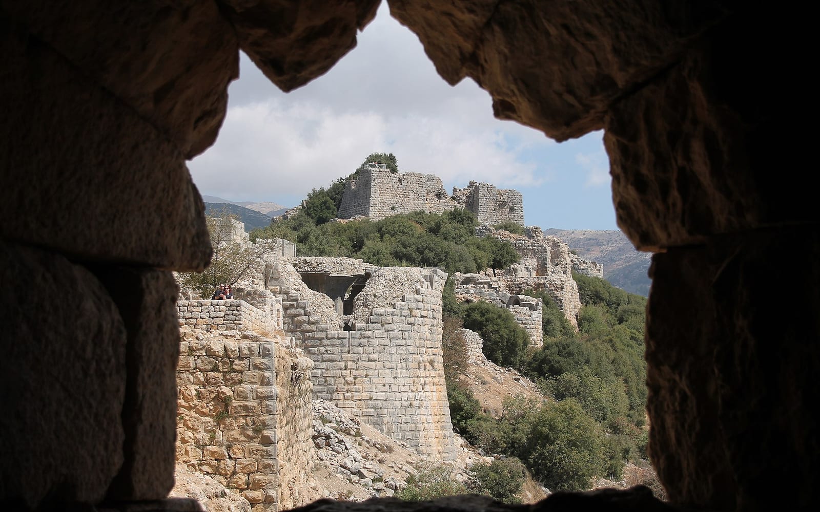
Nimrod Fortress — Qal’at Nimrod in Arabic, Mezudat Nimrod in Hebrew — is the largest surviving medieval castle in Israel, perched at 800 metres on a basalt ridge at the foot of Mount Hermon in the northern Golan Heights. Its walls run for over 420 metres, its 21 towers span from the 13th to the 15th century, and the view from the keep — across the Hula Valley, the Galilee hills, and into Lebanon — is among the most commanding from any hilltop site in the country.
Unlike the Crusader castles scattered across the coastal plain and Jordan Valley, Nimrod is an Ayyubid and Mamluk fortress: it was built by Muslim rulers to defend the Golan and Damascus road from both Crusader incursion and the expanding Mongol threat. Walking through it rewards the effort — its intact vaulted chambers, spiral staircases, and a rare in-situ Arabic inscription from 1275 CE bring the medieval Levant closer than almost any other site in northern Israel.
History: Ayyubid origins and the Mamluk expansion
The castle was founded in 1229 CE by Al-Aziz Uthman, nephew of the Ayyubid ruler of Damascus, on a strategic spur overlooking the Banias valley and the Damascus road — the key trade and military route linking the interior of Syria with the Mediterranean coast. The political context was acute: the same year, Crusader emperor Frederick II negotiated the Treaty of Jaffa and temporarily recovered Jerusalem, alarming the Ayyubid court, which needed to consolidate control of the northern approach roads.
A common misconception labels Nimrod a Crusader castle. It is not. The Crusaders built fortresses elsewhere in the region, but Nimrod was conceived and constructed by Ayyubid Muslims as a check on Crusader expansion northward. The name “Nimrod” is a later popular attribution — drawn from the biblical hunter Nimrod, son of Cush — and was not the historical name of the fortress in medieval times.
After the Mongol invasions of 1260, the Mamluk sultan Baibars reinforced and expanded the fortress substantially. His engineers added the outer defensive walls, deepened the moat, and constructed the massive south-western tower — the most imposing structure still standing. A carved Arabic inscription dated 1275 CE placed near the western gate by Baibars remains in situ; it is one of the few surviving Ayyubid-Mamluk inscriptions in an Israeli national park. The fortress was abandoned in the early 16th century as the Ottoman Empire consolidated control of the Levant and the strategic rationale for the castle diminished.
What to see: a circuit of the fortress
The INPA trail circuit begins at the car park and leads up to the eastern gatehouse — the main entrance, flanked by two towers and still commanding in scale. The gatehouse passage enters through a dog-leg corridor (a standard medieval defensive design forcing attackers to slow and expose themselves). From here the circuit moves through the following key areas:
The outer walls and eastern towers: the eastern section of the fortress preserves the highest surviving wall sections. Several towers have accessible interiors via stone stairways; the views from the upper levels toward the Hula Valley and the Lebanese border ridgeline are exceptional.
The great hall (Khan): a large vaulted hall in the middle section of the fortress, used for storage and troop assembly. The vaulting is intact and the scale conveys how large a garrison the fortress was designed to accommodate.
The keep and south-western tower: the tallest surviving structure — four storeys of Mamluk construction rising above the lower court. Climbing to the uppermost accessible level gives the widest panoramic view of the site: north to Mount Hermon’s snowfields (in winter and spring), west into the Upper Galilee, and south over the Sea of Galilee on clear days.
The secret staircase: a concealed 27-metre passage descending inside the castle wall from near the keep down toward the moat — used for covert communication between the upper fortress and the outer defences. The passage is accessible with a torch (headlamp recommended); it is one of the features that makes Nimrod genuinely interesting to explore beyond the views.
The Baibars inscription: near the western gate, the carved stone panel commissioned by Baibars in 1275 CE records his patronage of the fortress in formal Arabic calligraphy. It is small enough to overlook but worth finding — INPA information panels on-site guide visitors to it.
Allow 1.5–2.5 hours for the full circuit. The uneven medieval stonework and some steep internal staircases make this challenging for young children and those with mobility difficulties; it is not suitable for pushchairs or wheelchairs in most sections.
| Detail | Information |
|---|
| INPA pass | Valid (Green and Brown cards) |
| Entry fee | ~₪22 adult without pass; verify at gate or parks.org.il |
| Opening hours | 08:00–17:00 summer / 08:00–16:00 winter; check parks.org.il for current hours |
| Circuit length | ~1.5 km |
| Duration | 1.5–2.5 hours |
| Difficulty | Moderate — uneven stonework, steep internal stairs; not pushchair-accessible |
| Children | Not recommended for children under ~8; steep staircases require care |
| Facilities | Car park, picnic area, basic toilets; no café on site |
| Getting there | Route 989 off Highway 99 between Kiryat Shmona and Majdal Shams; signposted |
| Nearest town | Kiryat Shmona (15 km west); Majdal Shams (8 km east) |
Combining Nimrod with Banias and Tel Dan
The fortress is the northern anchor of the best single-day circuit in the Golan Heights:
Nimrod + Banias (the most popular combination): Banias Nature Reserve is 5 km southwest of the fortress on the same road. The reserve covers the ancient Pan cave sanctuary, the ruins of Herod Philip’s city (Caesarea Philippi), and — on the longer trail — the Banias waterfall, one of the largest in Israel. Allow 2 hours at Banias after Nimrod. Both are covered by the INPA pass. See the Golan Heights guide for the full Banias description.
Adding Tel Dan (a longer day): Tel Dan Nature Reserve, 15 km west of Nimrod via Highway 99, preserves a 3,700-year-old Canaanite mudbrick gate — the oldest surviving arched city gate in the world — alongside the Dan spring and the archaeological layers of ancient Dan where Jeroboam set up one of his two golden calves (1 Kings 12:29). The nature trail is flat and shaded, making it a good late-afternoon stop after the exposed fortress walk. Also covered by the INPA pass.
Adding a Druze village lunch: Majdal Shams, 8 km east of Nimrod on the road toward Mount Hermon, is the main Golan Druze town — the best place to stop for traditional mansaf, kibbeh, or freshly baked pita with labneh. A late-morning Nimrod visit, Druze lunch in Majdal Shams, then Banias waterfall in the afternoon is a well-balanced day.
Mount Bental viewpoint: 30 km south of Nimrod, Mount Bental’s observation platform above the Syrian buffer zone is the Golan’s most dramatic viewpoint and makes a logical sunset stop on the return south. See the Golan Heights guide for full coverage.
Getting there
By car: Nimrod Fortress is most easily reached from the north via Highway 99 (Kiryat Shmona to Majdal Shams road) — the signposted turn onto Route 989 is approximately 10 km east of Kiryat Shmona. From Tiberias, take Highway 90 north to Kiryat Shmona (55 km, approximately 1 hour), then Highway 99 east. From Tel Aviv, allow 2.5–3 hours via Highways 2 and 90.
Rental car: there is no practical public transport to the fortress. A rental car picked up in Tiberias, Haifa, or Tel Aviv is the recommended approach. The road to the fortress is paved and navigable in any standard car.
Guided day trip: if you prefer not to drive the Golan, guided day trips from Tel Aviv, Haifa, and Tiberias include Nimrod Fortress on their northern Golan itinerary alongside Banias and other sites. Use the GetYourGuide CTA above to compare operators and departure points.
Fuel: fill up in Kiryat Shmona before heading east — petrol stations on the Golan plateau are limited. The nearest reliable stations are in Kiryat Shmona and Katzrin (35 km south).