Israel is a remarkably compact country for UNESCO World Heritage Site hunting. Its 9 inscribed sites span prehistoric cave art, Nabataean trading cities, Crusader fortifications, Jewish catacombs, Bauhaus apartment blocks and one of the world’s great religious monuments — all within a country roughly the size of New Jersey.
This guide explains what each site is, why it was inscribed, how accessible it is, and what to see when you get there.
Israel’s 9 UNESCO World Heritage Sites at a glance
| Site | Inscribed | Region | INPA Pass? | Visitor infrastructure |
|---|
| Masada National Park | 2001 | Dead Sea | Yes | Excellent |
| Old City of Acre (Akko) | 2001 | North coast | No | Excellent |
| White City of Tel Aviv | 2003 | Tel Aviv | No (public streets) | Good |
| Biblical Tels (Megiddo, Hazor, Beer-Sheba) | 2005 | Multiple | Yes | Good |
| Incense Route — Desert Cities | 2005 | Negev | Yes | Moderate–basic |
| Bahá’í World Centre, Haifa | 2008 | Haifa | No (free guided tours) | Excellent |
| Nahal Me’arot / Mount Carmel Caves | 2012 | Haifa area | Yes | Good |
| Caves of Maresha & Beit Guvrin | 2014 | Judean foothills | Yes | Excellent |
| Necropolis of Beit She’arim | 2015 | Jezreel Valley | Yes | Good |
1 · Masada National Park (2001)
Why inscribed: Outstanding example of Late Second Temple Jewish architecture and the site of one of history’s most dramatic last stands. The Roman siege works surrounding the plateau are among the best-preserved anywhere in the world.
What it is: Masada is a flat-topped mesa rising 400 metres above the Dead Sea shore. Herod the Great built an elaborate desert palace on its summit between 37 and 31 BCE; following the Jewish revolt against Rome, a group of Sicarii rebels held the fortress until 73 CE before the Romans finally breached the walls. The story — including the mass suicide tradition recorded by Josephus — became foundational to Israeli national identity.
What to see: Herod’s Northern Palace (three-tiered; mosaic floors; vertiginous views over the Dead Sea), the Byzantine church with its mosaic floor, the ancient synagogue (one of the world’s oldest), the western and southern palaces, and the intact Roman circumvallation wall visible far below the cliff edge. The view across the Dead Sea to the mountains of Jordan is extraordinary.
Access: By cable car (opens 08:00, closed ~1 hour before park closing) or on foot via the Snake Path (1.5 km, 45–75 minutes, opens 04:00 for sunrise hikers). The National Parks Pass is valid. Verified current hours at parks.org.il before visiting, as they vary by season. See the Masada visitor guide for a detailed comparison of access options.
2 · Old City of Acre / Akko (2001)
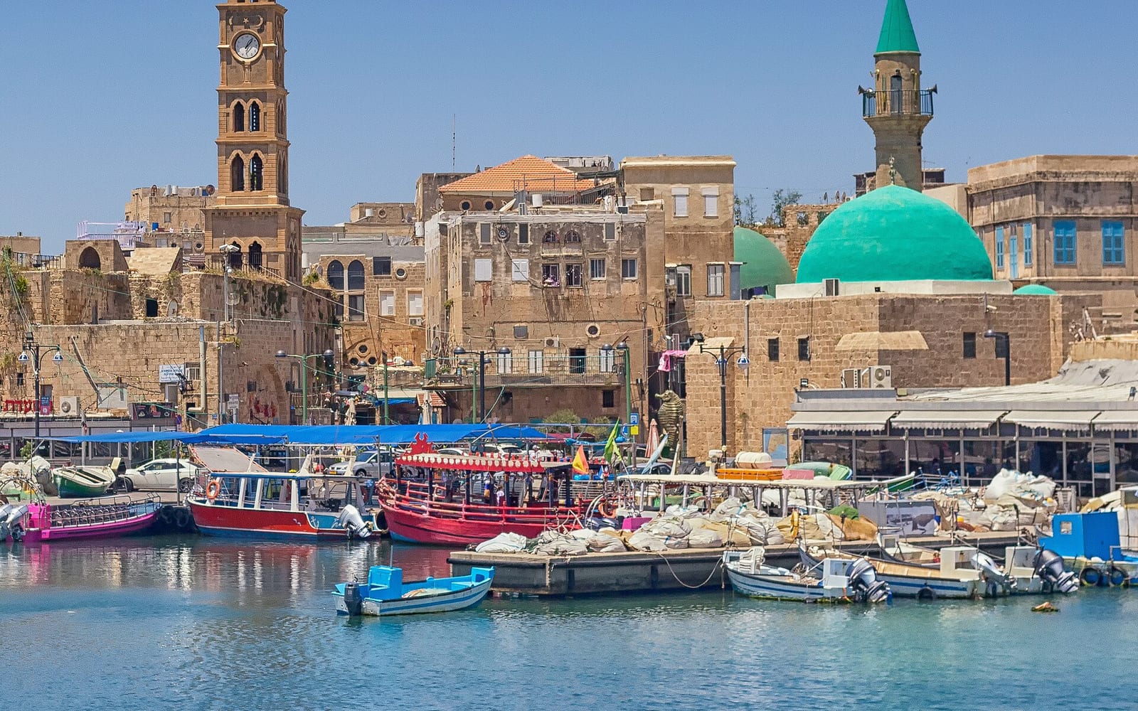
Why inscribed: An outstanding example of an Ottoman-era fortified town built on the remains of a Crusader-period town — a cultural landscape of exceptional universal value.
What it is: Akko (Acre) has been continuously inhabited for over 4,000 years. The current walled old city dates largely from the 18th-century Ottoman reconstruction; beneath it, largely intact Crusader streets, halls and tunnels survive — one of the most remarkable medieval underground cities in the world. The two layers — Crusader underground and Ottoman above-ground — exist simultaneously and are both accessible to visitors.
What to see: The Knights’ Halls (Crusader refectory and halls of the Hospitallers), the Al-Jazzar Mosque (Ottoman, 1781; open to visitors outside prayer times; modest dress required), Hammam Al-Pasha (restored 18th-century bathhouse; museum), the Crusader Tunnel connecting the fortress to the port, the ancient market street and the walls with sea views. The old city’s stone alleyways are deeply atmospheric to wander at any time of day.
Access: Akko is directly on the coastal railway line from Tel Aviv (Haifa, then change or continue); it is one of the most accessible UNESCO sites without a car. The Crusader underground halls have a separate admission fee. No National Parks Pass coverage — check individual attraction entry fees at the Akko Visitor Centre on arrival. See the Akko (Acre) guide for full logistics.
3 · White City of Tel Aviv (2003)
Why inscribed: An outstanding example of new town planning and architecture in the early 20th century — the largest concentration of Bauhaus/International Style buildings in the world.
What it is: Between the 1930s and 1950s, Jewish architects trained at the Bauhaus school in Germany — many of whom fled the Nazi rise to power — settled in the British Mandate city of Tel Aviv and built approximately 4,000 buildings in the modernist International Style. The result is the densest concentration of early-20th-century modernist architecture anywhere on the planet.
What to see: The key streets are Rothschild Boulevard (the most picturesque, lined with trees and café terraces), Dizengoff Square and the surrounding grid, and Bialik Street near Allenby. Standout buildings include the Engel House at 84 Rothschild (Zeev Rechter, 1933 — Israel’s first “pilotis” building, raised on pillar legs), the Cinema House cultural centre, and the Oneg Shabbat building. The Bauhaus Center at 77 Dizengoff Street runs guided walking tours (typically Friday and Sunday at 10:00 — verify current schedule at bauhaus-center.com).
Access: Walk directly from central Tel Aviv. No admission fee — the White City is public streets. Best explored on foot in the early morning when light is soft and pedestrian traffic is light. The self-guided walk takes 2–3 hours.
4 · Biblical Tels: Megiddo, Hazor, Beer-Sheba (2005)
Why inscribed: Three ancient Bronze and Iron Age cities that represent the characteristic form of the Iron Age Canaanite and Israelite city — demonstrating the development of urban planning and monumental architecture across several millennia.
What they are: A “tel” is a mound of accumulated settlement debris built up over thousands of years of occupation, destruction and rebuilding. These three tels share the unusual feature of tri-chambered gates — a monumental gate design mentioned in the Hebrew Bible as the work of King Solomon. All three are national parks.
- Tel Megiddo (Armageddon): Situated in the Jezreel Valley; 26 layers of occupation from 7000 BCE to 586 BCE; the Canaanite temple complex is outstanding; the underground water tunnel is one of the most impressive ancient engineering works in Israel. The site’s association with the Book of Revelation’s “Armageddon” brings significant Christian pilgrimage traffic. See the Tel Megiddo guide for full details.
- Tel Hazor: In the Upper Galilee (Route 90 north of Tiberias); the largest tel in Israel; over 40 layers; an excellent museum on-site explains the excavation history and the Canaanite/Israelite city’s role as a major Bronze Age regional capital.
- Tel Beer-Sheba (Beer-Sheva): A compact, beautifully excavated Iron Age city at the edge of the modern city of Beer-Sheva; the 4-chambered gate and orthogonal street layout are among the best-preserved Iron Age urban remains in the region.
Access: All three require a car. The National Parks Pass is valid at all three. Tel Megiddo is 30 km south-east of Haifa; Tel Hazor is in the upper Galilee near Kiryat Shmona; Tel Beer-Sheba is at the southern edge of Beer-Sheva city.
5 · Incense Route — Desert Cities of the Negev (2005)
Why inscribed: The Negev desert cities of Haluza, Mamshit, Avdat and Shivta represent an outstanding example of Nabataean trade cities along the ancient Incense Route — a 2,000-km overland trading route that carried frankincense and myrrh from the Arabian Peninsula to the Mediterranean.
What they are: The Nabataeans were a sophisticated trading civilisation (c.4th century BCE to 1st century CE) who built and maintained a network of desert settlements, caravanserais and water cisterns across the Negev. When incorporated into the Roman Empire in 106 CE, the cities continued to thrive. They were eventually abandoned in the 7th–8th centuries CE.
- Avdat (Ovdat): The most developed site for visitors; INPA park with visitor centre; Nabataean temple complex, Byzantine churches with mosaic fragments, Roman bathhouse, wine press, hilltop acropolis with panoramic Negev views. Entry via the National Parks Pass.
- Mamshit (Mamshit National Park): Compact and well-preserved near Dimona; Byzantine mosaic floor in the church; Nabataean building facades. National Parks Pass valid.
- Shivta: Remote, largely unexcavated Byzantine town (6th–8th century CE) 50 km south of Beer-Sheva; free access; minimal infrastructure; spectacular in its solitude. A 4×4 or high-clearance vehicle is recommended for the final approach.
- Haluza (Elusa): The original Nabataean capital of the Negev, mostly unexcavated; free access; for serious archaeology enthusiasts only.
Access: Avdat is the most accessible, on Route 40 near Sde Boker (30 km north of Mitzpe Ramon). Mamshit is east of Dimona. Shivta and Haluza require more planning and a vehicle with reasonable clearance. See also the Mitzpe Ramon guide for combining Avdat with a Negev day.
6 · Bahá’í World Centre, Haifa (2008)
Why inscribed: The two groups of buildings (the Shrine of Báb in Haifa and the Shrine of Bahá’u’lláh in Akko) form the spiritual and administrative centre of the Bahá’í Faith — an outstanding example of sacred landscape integrating architecture and nature.
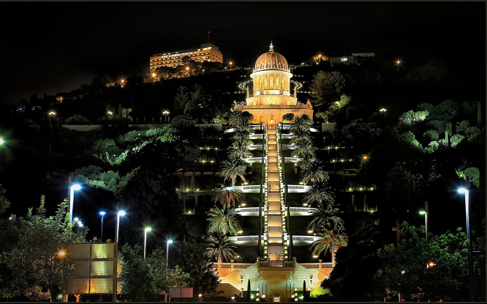
What it is: The Bahá’í Faith, founded in 19th-century Persia, counts between 5 and 8 million adherents worldwide. Haifa is its international spiritual headquarters because its founder, Bahá’u’lláh, was imprisoned by the Ottoman authorities and exiled to Akko (then part of the Ottoman Empire). The golden-domed Shrine of the Báb sits at the centre of 19 formal terraces cascading down Mount Carmel, with the bay and port of Haifa as backdrop.
What to see: The 19 terraces from top to bottom are the main draw — one of the world’s great formal garden designs, symmetrically perfect and maintained with extraordinary precision. The Shrine of the Báb itself (the golden dome) is the holiest site in the Bahá’í Faith; respectful visitors of all beliefs are welcome in the outer gardens. Photography is welcomed throughout the terraces. Photography inside the Shrine is not permitted.
Access: Free guided tours of the full terrace descent run Monday–Friday at noon (English). No reservation required. Individual access to the lower terraces and immediate shrine gardens is possible daily. Verify current access hours and tour schedule at bahai.org.il — arrangements are managed carefully by the World Centre. See the Bahá’í World Centre guide for full visitor information.
7 · Nahal Me’arot / Mount Carmel Caves (2012)
Why inscribed: The four prehistoric cave sites in Nahal Me’arot (Wadi el-Mughara) on the Carmel ridge provide an outstanding record of 500,000 years of human cultural evolution — including some of the earliest evidence of Neanderthal and early modern human burials, tool use, and symbolic behaviour.
What they are: The Skhul, Tabun, el-Wad, and Kebara caves contain one of the world’s most important palaeolithic archaeological sequences. The 1929–1934 excavations found Neanderthal and early human skeletal remains in the same geological layers — evidence that the two species coexisted in this region. The caves also contain Israel’s longest uninterrupted prehistoric sequence, from Acheulean hand axes (c.500,000 BCE) through to Natufian culture (c.15,000–11,500 BCE), the culture that is thought to have pioneered the transition to farming.
What to see: The visitor centre at Nahal Me’arot (Carmel Caves National Park) explains the stratigraphy and significance through well-designed exhibits; you walk through two of the caves. The site is an honest encounter with deep time — the layers of human presence are visually compelling even without specialist knowledge.
Access: Located on the Carmel coast, 15 km south of Haifa, near Zikhron Yaakov. Accessible by bus 202 from Haifa (Hof HaCarmel station) — ask the driver for the Carmel Caves stop. The National Parks Pass is valid. Entry includes the visitor centre and guided cave walk. Check hours at parks.org.il.
8 · Caves of Maresha and Beit Guvrin (2014)
Why inscribed: The caves of Maresha and Beit Guvrin are outstanding examples of a vast network of man-made subterranean spaces — over 3,500 caves cut into the soft chalk bedrock over 2,000 years, used for olive oil production, limestone quarrying, burial, water cisterns, dove breeding and habitation.
What they are: Beit Guvrin National Park contains the largest accessible complex of ancient underground caves in Israel. The most spectacular are the “Bell Caves” — soaring underground chambers up to 12 metres high, domed and circular, with shafts of natural light cutting through from above — along with columbaria (dove breeding caves, with hundreds of carved niches in the walls) and amphora production rooms. The site spans several historical periods: Hellenistic Maresha (3rd–2nd century BCE), Roman-period Eleutheropolis, and Byzantine occupation.
What to see: The Bell Caves are the highlight — visually dramatic and unlike anything else in Israel. The Sidonian burial caves have vivid Hellenistic-period painted plaster (verifiable dates from signage — always check current guided tour arrangements at the site). The Crusader church ruins above ground complete a site that spans 2,300 years of history.
Access: Located near Beit Guvrin in the Judean foothills, between Beer-Sheva and Jerusalem (Route 35, turn-off near Beit Guvrin town). A car is the practical option, though some buses run from Beer-Sheba and Kiryat Gat. The National Parks Pass is valid. Allow 2–3 hours for a thorough visit. Check current opening hours at parks.org.il.
9 · Necropolis of Beit She’arim (2015)
Why inscribed: Beit She’arim is an outstanding example of a Jewish necropolis that became a focus of Jewish national and religious life after the destruction of the Second Temple, demonstrating a significant change in Jewish art and architecture under Hellenic influence.
What it is: In the 2nd–4th centuries CE, Beit She’arim became the site of the Sanhedrin under Rabbi Judah ha-Nasi (compiler of the Mishnah). Jews from across the diaspora — from as far as Yemen, Palmyra, and Phoenicia — were brought here for burial, making it a pan-Jewish necropolis of extraordinary cultural significance. The catacombs contain hundreds of decorated stone sarcophagi with Aramaic, Greek and Hebrew inscriptions alongside Jewish symbols, mythological motifs and human figures — marking a significant departure from the aniconic tradition of early Judaism.
What to see: The cave catacombs themselves — entered through monumental doorways — are remarkable: long corridors lined with carved stone sarcophagi in multiple chambers, with Greek epithets, menorahs, and unexpectedly playful carved faces. The excavated basilica above ground is one of Israel’s finest ancient architectural remains. The museum at the park entrance provides good historical context.
Access: Located near the Tivon Junction in the Jezreel Valley, 20 km south-east of Haifa. Accessible by bus from Haifa (alight at Beit She’arim Junction, 1 km walk). The National Parks Pass is valid. Check hours at parks.org.il. The site combines well with a visit to Tel Megiddo (30 km away), both in the Jezreel Valley.
Planning a UNESCO road trip in Israel
Three-day northern circuit (Haifa base)
Day 1 — Haifa: Bahá’í Terraces guided noon tour; afternoon: Nahal Me’arot Carmel Caves (40 min south on coastal highway).
Day 2 — Jezreel Valley: Tel Megiddo (morning) + Beit She’arim (afternoon). 40 km apart; INPA pass saves ₪70+.
Day 3 — Akko: Full day in the UNESCO Old City — Crusader halls, Al-Jazzar Mosque, port walls, market.
Two-day southern circuit (car essential)
Day 1 — Beit Guvrin / Beer-Sheba Tel: Bell Caves (2–3 hours) + Tel Beer-Sheba (40 min drive; 1.5 hours).
Day 2 — Negev (Avdat + Mitzpe Ramon): Avdat Incense Route city (1.5 hours) + Mitzpe Ramon crater for overnight stargazing.
White City + Masada (Jerusalem base)
The White City is best explored as a half-day self-guided walk from central Tel Aviv. Masada is a full-day excursion from Jerusalem or the Dead Sea. See the 7-day road trip itinerary for a route connecting both.
Practical tips for UNESCO site visits
INPA National Parks Pass: The Israel National Parks Pass covers entry to 7 of the 9 sites (all except the White City self-guided walk and Akko’s Crusader halls). If you are visiting 3 or more INPA parks, the pass is almost always cheaper than buying individual tickets. Use the parks pass calculator to check the maths for your itinerary.
Opening hours: UNESCO sites are managed by different authorities — INPA (national parks), the Bahá’í World Centre (Haifa), and the Akko Development Corporation. Hours vary significantly by season and site. Always check parks.org.il for INPA sites and the specific authority’s website for Haifa and Akko before visiting.
Combining with existing guides: Each major site on this hub links to a dedicated guide — see the site entries above and the Jewish heritage guide for the broader cultural context. For transport logistics, the car rental guide covers the practicalities of hiring a car in Israel.
Photography: All UNESCO sites permit exterior photography. Interior photography restrictions vary by site — the Bahá’í Shrine interior and active synagogues at Beit She’arim do not permit photography; always follow on-site signage.