The Israel National Trail — the Shvil Yisrael — is one of the world’s great long-distance walks: 1,100 km from the Galilee foothills to the Red Sea, blazed in white, blue and orange, and strung with a legendary network of volunteer hosts who take in hikers, feed them, and send them on their way. National Geographic placed it among the world’s top long-distance trails. You do not need 60 days to experience it. This guide covers the best sections for tourists: how to pick a segment, how long each takes, what logistics you need, and how to connect with the trail-angel culture that makes the Shvil something more than a walk.
Why the INT rewards section hiking
A full Shvil thru-hike is a serious expedition — 45 to 60 days, careful water planning for the desert south, and the logistical complexity of a two-month trip. Most tourists rightly choose a section: three to seven days on the most scenically rewarding stretch for their itinerary. The trail covers enough variety within each major region that a week of section hiking feels complete in itself, and the sections described below can each be reached, started and finished with manageable logistics.
The trail system at a glance
| Feature | Details |
|---|
| Total length | ~1,100 km (Dan → Eilat) |
| Blazes | Three-stripe orange / blue / white |
| Trail angels | Informal volunteer network; TING directory |
| Navigation app | AllTrails (offline), Amud Anan, Wikiloc |
| INPA passes | Valid at reserves along the trail; parks.org.il |
| Best season | Nov–Apr (north year-round mornings; desert Oct–Mar only) |
Section 1 — Upper Galilee & Golan (6–8 days)
Trail segment: Dan → Rosh Pina (roughly 130 km)
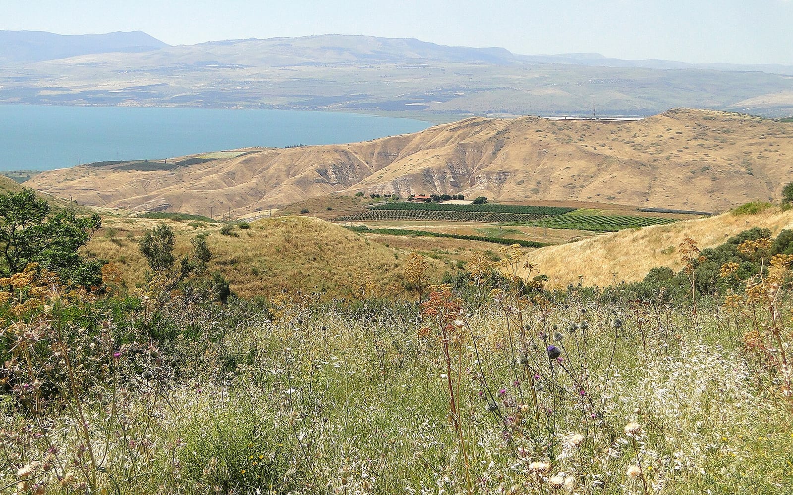
This is the most forested, well-watered and accessible stretch of the entire INT. It runs through the Hula Valley wetlands, the Biriya Forest, springs and oak-covered Galilee ridges, and the basalt landscape of the southern Golan foothills. Trails are well-marked and water is available regularly — the easiest introduction to multi-day INT hiking.
Highlights:
- Tel Dan Nature Reserve — the northern starting point; ancient Israelite gate complex and the Dan Spring, one of the Jordan River’s three headwaters. The trail begins here in lush riparian woodland.
- Nimrod Fortress (Kala’at Nemrod) — a dramatic Crusader-era castle on a basalt ridge with sweeping views; reached on the trail’s Golan segment.
- Banias / Hermon Stream Nature Reserve — the third Jordan River headwater; waterfall and Roman temple of Pan ruins directly on the trail.
- Biriya Forest & Mount Meron — Israel’s highest peak (1,208 m); the trail climbs through extensive cedar and pine plantation with wide Galilee views.
- Rosh Pina — a historic moshav and wine-village that makes a natural end to the segment; accommodation, restaurants and transport connections south.
Logistics: The Rosh Pina–Kiryat Shmona bus runs regularly. Trail angel density in the Galilee is the highest on the full trail — expect at least three or four offers of hospitality per thru-day during the main October–May season. A rental car is useful for one-way access but Egged buses reach the Dan area and Rosh Pina.
Water: Plentiful springs and streams in this section. Carry standard 2–3 litres but do not worry about desert-style water planning.
Section 2 — Mount Carmel (3–4 days)
Trail segment: Zikhron Ya’akov → Isfiya (roughly 60 km)
The Carmel section is the shortest and most logistically compact option — ideally suited for hikers based in Haifa who want a few days on the trail before or after a city visit. The route climbs through the UNESCO-candidate Carmel mountain forest, passes Druze villages, and delivers panoramic views of the Mediterranean coast and the Jezreel Valley.
Highlights:
- Mount Carmel UNESCO biosphere — Mediterranean oak-carob-pine forest; the Carmel is one of the country’s most biologically rich zones. Spring brings spectacular wildflowers.
- Druze village of Isfiya — the natural northern end of this section; an opportunity to eat in a Druze restaurant (hearty grilled meat and flatbread spreads) before transport back south.
- Nahal Me’arot prehistoric caves — UNESCO World Heritage Site just off the trail; four caves with Neanderthal and early modern human remains spanning 500,000 years.
- Mediterranean coast views — on clear days the trail ridge offers unbroken views from Haifa Bay south toward Tel Aviv.
Logistics: Haifa is the natural base for this section. The trail’s southern end is accessible by bus from Haifa. The northern Druze villages have infrequent but usable public transport. Car access makes the shuttling simple.
Water: Springs and village taps — manageable in any season.
Section 3 — Negev Highlands & Ramon Crater (5–7 days)
Trail segment: Beer Sheva → Mitzpe Ramon (roughly 120 km)
This is the dramatic heart of the southern trail — and the most demanding section for tourists. The Negev Highlands offer open sky, ancient Nabataean ruins, sand and limestone geology, and the Ramon Crater (Makhtesh Ramon), the world’s largest erosion crater: 40 km long, 500 m deep, and utterly unlike anywhere else in Israel. The trail runs along the crater rim and descends into the makhtesh floor.
Highlights:
- Tel Malhata & Tel Aroer — Nabataean and Iron Age sites along the early stages.
- Sde Boker — the desert kibbutz where David Ben-Gurion lived and is buried; a natural overnight stop with a hostel, cafeteria and the Ein Avdat gorge just south (one of the finest short hikes in the Negev, with Byzantine cliff monastery ruins reflected in a clear green pool).
- Ein Avdat National Park — the trail passes through this spectacular gorge. The pool at the base of the Ein Avdat waterfall is a famous highlight; water is clear and cold.
- Ramon Crater rim walk — the section approaching Mitzpe Ramon follows the crater’s northern rim; the first view into the makhtesh is one of those genuinely stopping moments.
- Makhtesh Ramon floor — the crater’s geology is extraordinary: Jurassic sandstone striped in red, purple and cream; fossil ammonites; prism rocks; volcanic intrusions. The trail crosses the floor over about two days.
- Mitzpe Ramon — the small desert town on the crater rim; hostels, restaurants, the Ramon Crater Visitor Centre, and Israel’s premier stargazing after sunset.
Logistics: Beer Sheva is connected to Tel Aviv and Jerusalem by regular train. Mitzpe Ramon has Egged bus connections back to Beer Sheva. This section is car-optional; a hire car at Mitzpe Ramon for the final day is useful.
Water (critical): This section has long waterless stretches. Carry a minimum of 5 litres at all times on desert days. Resupply points exist at Sde Boker and specific road crossings — research each day’s water sources on the TING trail notes before you go. Do not underestimate this. Dehydration is the most common emergency in the Negev.
Section 4 — Eilat Mountains (3–4 days)
Trail segment: Mitzpe Ramon → Eilat (roughly 80 km, the final stretch)
The trail’s southern conclusion runs through an ancient desert landscape of multicoloured sandstone ridges. This is the most remote section — it passes through no settlements for its first two days — and arguably the most beautiful in terms of raw colour and geology.
Highlights:
- Yehoram Ramon Memorial — a small monument near the start of this section to the late singer and his reserve-duty IDF colleagues who died in a 2001 helicopter crash; a poignant and quietly observed tribute.
- Red Canyon (Nahal Shani) — a famous off-trail short hike in iron-red sandstone accessible from Route 12; usually done as a separate day from Eilat but the INT passes within reach. See the full Red Canyon guide.
- The colour ridge country — geological formations in ochre, purple, white and black; this stretch is one of the most-photographed segments of the entire trail.
- Eilat — the trail ends at the Coral Beach Nature Reserve on the Red Sea. Swimming in the Red Sea after a week of desert walking is the classic Shvil conclusion.
Logistics: Mitzpe Ramon has bus connections for access. Eilat has its own airport (ETM/Ovda). There is no water between km 0 and the first road crossing — carry at least 5 litres from the start and cache or resupply carefully.
The trail-angel network
The trail angel (מלאך שביל) culture is one of the things that makes the INT more than a long walk. Israeli families along the route — farmers, retirees, kibbutz members, anyone who has hiked the trail themselves — open their homes to passing Shvil hikers, typically offering a bed or a patch of garden to pitch a tent, a hot shower and a shared meal. There is no payment expected, though a contribution to food costs is courteous.
How to connect with trail angels:
- The Shvil Talk Facebook group (search “Shvil Talk”) is the primary community for hikers and trail angels; post your section and dates and angels in that area will often reach out.
- The TING (Israel National Trail & Hiking Association) publishes a PDF trail-angel directory; check the current version at israeltrail.net.
- The Amud Anan and Shvil Israel apps include crowd-sourced trail-angel contacts.
- Register in advance — trail angels are volunteers with their own families and schedules; a few days’ notice is the norm.
Trail angels are not a formal infrastructure. They may be full, unavailable, or simply not along your section. Plan alternative accommodation (kibbutz guesthouses, INPA campgrounds, Mitzpe Ramon hostels) for every night, and treat trail-angel hospitality as a bonus rather than a given.
Practical INT logistics
Getting to and from section start/end points
Most INT section trailheads are reached by public transport only with difficulty — this is one context where a hire car genuinely transforms the experience. A common approach: two hikers drive both vehicles to the exit trailhead, leave one there, drive together to the entrance trailhead, and recover the first car at the end.
Egged buses reach Dan (limited frequency), Beer Sheva (regular), Mitzpe Ramon (daily), and Eilat (multiple daily). For the Galilee sections, the Rosh Pina area has reasonable bus and sherut connections.
INPA campgrounds on the route
The INT passes through or adjacent to approximately 15–20 INPA designated campgrounds. These range from basic (composting toilets, no showers, ~₪35–50/person) to full facilities (hot showers, covered kitchen, BBQ pits, ~₪65–100/person). Advance booking via parks.org.il is essential at peak periods (Sukkot, Passover, school holidays). The Israel National Parks Pass covers most INPA site entry fees along the trail, including nature reserves you pass through.
Wild camping is prohibited inside INPA-managed areas. Outside reserve boundaries, the general rule is “leave no trace” — this is respected culture, not optional.
Gear essentials for INT section hiking
| Item | Why it matters on the INT |
|---|
| 3-litre water capacity minimum | Desert sections have no natural water for 20+ km |
| Spiral tent stakes | Rocky limestone ground eats regular pegs |
| Head torch + spare batteries | Dawn starts and navigating camp at night |
| Ankle-support boots (not trail runners) | Rocky terrain, loose basalt, dry streambed crossings |
| AllTrails or Amud Anan offline | Signal-free desert; GPS is the backup brain |
| Sleeping bag rated to 5°C | Desert nights drop sharply even in spring |
| Sunscreen SPF 50+ | UV index above 10 year-round in the Negev |
Safety
The INT is well-maintained and well-marked; hundreds of international hikers complete it annually with no serious incidents. The two non-negotiable rules:
- Water. Underestimating water needs on the Negev sections is the most common emergency. Carry more than you think you need.
- Flash floods. Several INT sections cross dry riverbeds (wadis) that are subject to flash flooding in winter and spring. Never enter a wadi when rain is forecast anywhere in the catchment — the sky above you can be clear while a violent storm falls on the hills 20 km upstream. Obey INPA trail closure notices after rain.
Additional rules: tell someone your route and check-in date; download offline maps; start desert hiking days by 5–6 am; carry a whistle and basic first aid.
The TING publishes a trail-condition update and flash-flood advisory at israeltrail.net — check it before departing each section in the rainy season (November–March).
Linking the INT into your Israel itinerary
The Shvil runs the length of the country, which makes it easy to add a section to almost any Israel trip:
- Galilee section pairs naturally with a Galilee region itinerary — Tiberias, Nazareth and Banias are all either on or adjacent to the trail.
- Carmel section is a 3-day add-on to a Haifa stay, using the city as a base for daily shuttles.
- Negev / Ramon section combines with Mitzpe Ramon and possibly a Petra day-trip from Eilat at the end.
- The Israel National Parks Pass covers entry to many reserves the trail passes through — worth calculating before you set out.
- Consider a car rental for the southern sections where shuttle logistics are otherwise complex.
Israel’s long trail is its best-kept travel secret. Few experiences in the country match three days walking through the Negev at dawn, arriving in Mitzpe Ramon on empty legs, and eating the best hummus of your trip with strangers who are already friends.